
Create your free online surveys with SurveyMonkey, the world's leading questionnaire tool.
Author Archives: John Hayes
ASRT membership benefits
Save hundreds of dollars for yourself. Take advantage of members-only camping and other perks. Do good for others with an ASRT membership.
New for 2012: DISCOUNTS! Now your Alabama Scenic River Trail Membership buys you more than personal satisfaction of helping the state’s premiere recreational waterway organization. Now, your membership or renewal gets you rewards at most of the state’s outfitters, and a substantial discount off of ASRT events (you don’t even have to attend three events a year to see enough to make an individual membership FREE). Save on merchandise, launch fees and equipment rentals. Get river access exclusive to ASRT members. Just show your ASRT membership card to participating outfitters to save. For example, you’ll receive
- FREE trip including gear and shuttle
- 30% off nighttime rentals
- 20% and more off boat and gear rentals
Click here for a list of participating outfitters and their discounts. See the Events Section of this website for discounts on Alabama Scenic River Trail Events.
Here are some of the discounts and savings that your ASRT membership gets you:
- FREE launch on Terrapin Creek
- Half Price for ASRT member camping and special ASRT group rates at Bay Springs Campground, Weiss Lake
- Free camping in the pines for ASRT members at Little River Marina & Lodge on Weiss Lake
- Discounted primitive camping for ASRT members $5.00 each or 2 for $8.00 at Driftwood Campground on Weiss Lake
- Coosa Outdoor Center (Dirt Farm), Wetumpka area offers free camping with 24-hour hot showers for ASRT through paddlers
- Fort Toulouse—free tent camping on the two rivers point. Save a mile of walking to the campground! With advance call, or see manager on site.
- Lots of free camping on private land open only to ASRT members and through paddlers. Inquire!
Savings extend to trips, gear and services. Add that to the money you could save on Alabama Scenic River Trail events, and you could save enough to buy a boat!
In addition to savings on gear and going, you’re helping yourself and fellow boaters when you join. You’re supporting the work that Alabama Scenic River Trail is doing: establishing access, opening new campsites, getting more rivers and streams on the Trail, and establishing quality events around the state.
Click here for a list of participating outfitters and their discounts.
Bartram—Canal Island/Dead Lake
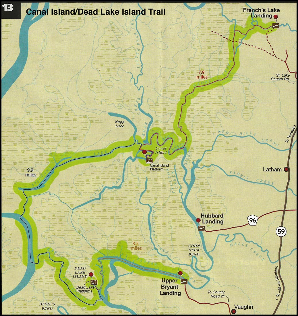
13. Canal Island/Dead Lake (3 days/2 nights)
Distance: 11 +/- miles
Start: French's Lake Coastal Access Kiosk
End: Upper Bryant Landing (private; public use fee associated)
Campsites: Spoonbill Sandbar, Two Rivers Point
Type of trail: river, creek, lake, and slough
Habitats: Old river channel, bottomland hardwood swamp, flowing creeks, side channel sloughs and backwaters
Reliability: good
Recommended water levels: Claiborne Dam river stages ranging from 10 to 19 feet on tailrace reading provide optimum water levels for this route. Levels from 15 to 18 are the absolute best for the Globe and Bear Creek systems. River stages above these values should be considered hazardous. For water level information at Claiborne Dam, call 1-888-771-4601 or visit http://water.sam.usace.army.mil or http://al. water.usgs.gov.
This multiple night trail would require the reservation of Canal island and Dead Lake Island floating platform campsites. The map shows this route leaving French's Lake Coastal Access Kiosk. The trail begins in Major's Creek, working its way down Globe Creek, upstream into Big Beaver Creek and Little Lake. Day one ends on the floating campsite located on the east side of Canal Island. On day two the paddlers explore Stiggins Lake, the Tensaw River and Bayou Tallapoosa. Day two ends on the floating campsite in the slough located on the west side of Dead Lake island. On day three the paddlers travel up Tensaw Lake to Upper Bryant Landing.
Bartram—Dead Lake Island
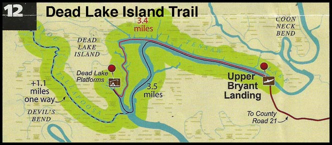
12. Dead Lake (2 days/1 night)
Distance: 7 +/- miles
Start: Upper Bryant Landing (private; public use fee associated)
End: Upper Bryant Landing (private; public use fee associated)
Campsites: Dead Lake Island
Type of trail: lake and slough
Habitats: bottomland hardwood swamp, side channel sloughs and backwaters
Reliability: excellent
Recommended water levels: Claiborne Dam river stages ranging from 6 to 19 feet on tailrace reading provide optimum water levels for this route. For water level information at Claiborne Dam, call 1-888-771-4601 or visit http://water.sam.usace.army.mil or http://al. water.usgs.gov.
The Dead Lake Island campsite has two floating platforms to accommodate larger groups. If your group is larger than eight, the reservation of both platform campsites is required. The map shows the Dead Lake Island trail leaving Upper Bryant Landing paddling west on Tensaw Lake. Day one ends at the floating platform located in the slough west of Dead Lake island. The return route is the same. The paddlers have the option of exploring the side creeks and sloughs as well as Tallapoosa Bayou.
Bartram—Canal Island
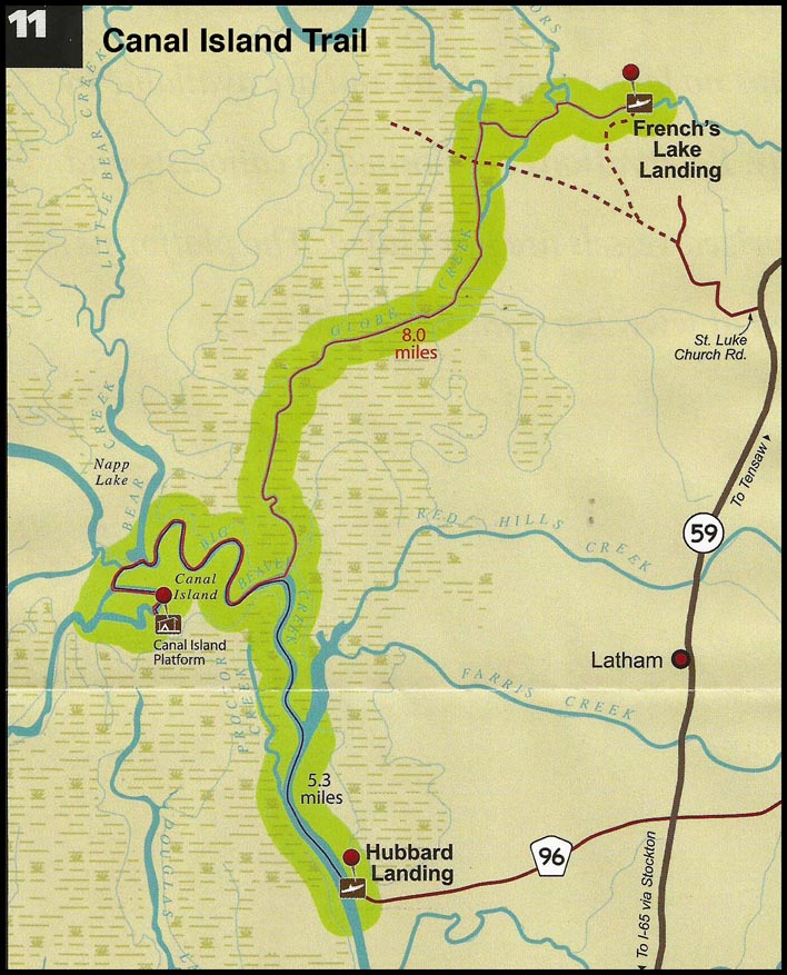
11. Canal Island (2 days/1 night)
Distance: 11 +/- miles
Start: French's Lake Coastal Access Kiosk
End: Hubbard Landing
Campsites: Canal Island Floating Platform
Type of trail: creek, lake, and slough
Habitats: bottomland hardwood swamp, flowing creeks, side channel sloughs and backwaters
Reliability: excellent
Recommended water levels: Claiborne Dam river stages ranging from 10 to 19 feet on tailrace readings provide optimum water levels for this route. Levels from 15 to 18 are the absolute best for the Globe and Bear Creek systems. River stages above these values should be considered hazardous. For water level information at Claiborne Dam, call 1-888-771-4601 or visit http://water.sam.usace.army.mil or http://al. water.usgs.gov.
The Canal Island overnight trail begins at the French's Lake Coastal Access Kiosk, located on the Forever Wild Land Trust’s Clearwater Tract. Get to French's Lake Coastal Access Kiosk by traveling north of Stockton, AL, on Highway 225/59, follow signs to the Upper Delta Wildlife Management Area and then follow signs to French's Lake Coastal Access Kiosk. The map shows French's Lake is a small slough- like area on Major's Creek, prior to the creek splitting into several channels. The multiple channels can be confusing, so it is important for users to closely follow the marked route. The first day begins with a paddle down Globe Creek which follows a generally southerly direction into Big Beaver Creek, then in a generally westerly direction upstream in Big Beaver Creek to Little Lake and ending at the floating campsite in the east side of Canal Island. Day two ends at Hubbard Landing after paddling back down Big Beaver Creek and into Tensaw Lake.
Bartram—Jug Lake
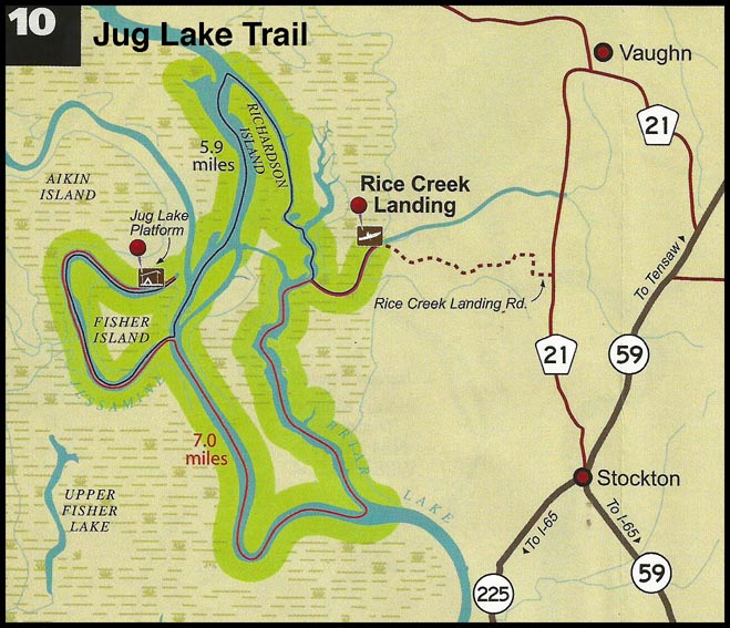
10. Jug Lake (2 days/1 night)
Distance: 13 +/- miles
Start: Rice Creek Landing
End: Rice Creek Landing
Campsites: Jug Lake
Type of trail: river, creek, lake, and slough
Habitats: Old river channel, bottomland hardwood swamp, flowing creeks, side channel sloughs and backwaters
Reliability: Good
Recommended water levels: Claiborne Dam river stages ranging from 6 to 19 feet on tailrace reading provide optimum water levels for this route. River stages above these values should be considered hazardous. For water level information at Claiborne Dam, call 1-888-771-4601 or visit http://water.sam.usace.army.mil or http://al. water.usgs.gov.
The map shows the Jug Lake trail paddling thru Rice Creek and up Briar Lake down Tensaw Lake on the east side of Larry Island. The trail proceeds to the west side of Larry lsland into Tensaw Lake/Tensaw River and down into Bayou Jessamine ending at the platform campsite located in Jug Lake. Day two returns to the Tensaw River via Bayou Jessamine and back up Briar Lake to Rice Creek.
Bartram—Spoonbill Sandbar/Two Rivers Point
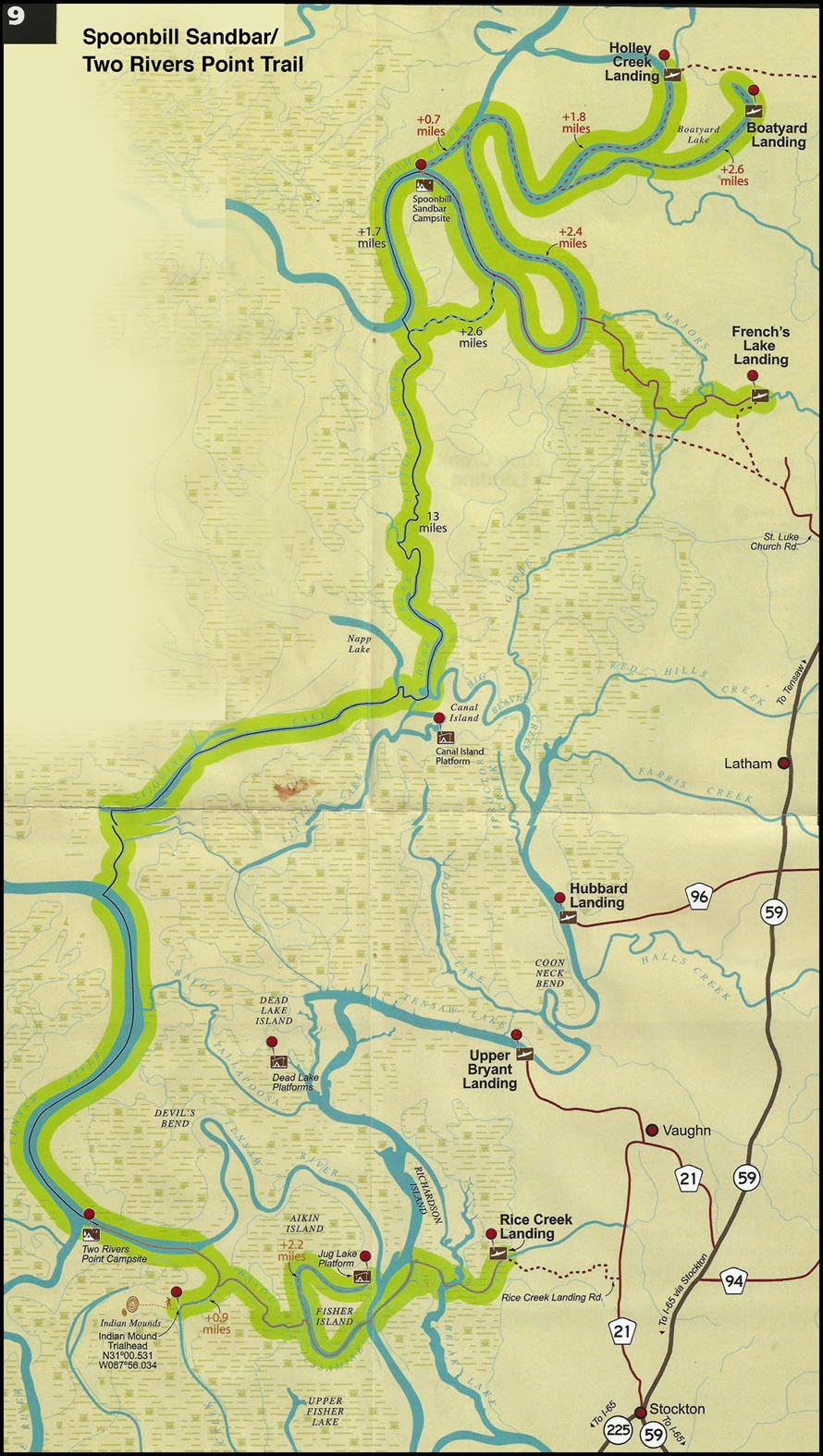
9. Spoonbill Sandbar/Two Rivers Point (3 days/2nights)
Distance: 30 miles
Start: French's Lake Coastal Access Kiosk
End: Rice Creek Landing
Campsites: Spoonbill Sandbar, Two Rivers Point
Type of trail: river, creek, lake, and slough
Habitats: old river channel, bottomland hardwood swamp, flowing creeks, side channel sloughs and backwaters
Reliability: Good
Recommended water levels: Claiborne Dam river stages ranging from 10 to 19 feet on tailrace reading provide optimum water levels for this route. Levels from 15 to 18 are the absolute best for the Globe and Bear Creek systems. River stages above these values should be considered hazardous. For water level information at Claiborne Dam, call 1-888-771-4601 or visit http://water.sam.usace.army.mil or http://al.water.usgs.gov.
Overnight Route # 3 is a combination of routes #1 and #2, which begins at French’s Lake Coastal Access Kiosk, Holley Creek or Boatyard Lake Landings. Both of the latter locations are privately owned, but allow for public use in the form of fee-associated boat launching and overnight vehicle parking. The map shows the trail begins in Major‘s Creek working its way to the old Alabama River channel. Day one ends at the Spoonbill
Sandbar campsite. Day two proceeds down the Alabama River to Little Bear Creek, Bear Creek, Stiggins Lake and the Tensaw River. Day two ends at the Two Rivers Point campsite. On day three the paddlers proceed down the Tensaw River and then into Bottle Creek, connecting to Bayou Jessamine, and then out to Rice Creek Landing after crossing the Tensaw River and Briar Lake.
Bartram—Spoonbill Sandbar
8. Spoonbill Sandbar (2 days/1 night)
Distance: 16 miles
Start: French's Lake Coastal Access Kiosk
End: Hubbard Landing (private; public use fee associated)
Campsites: Spoonbill Sandbar
Type of trail: creek, lake, and slough
Habitats: bottomland hardwood swamp, flowing creeks, side channel sloughs and backwaters
Reliability: excellent
Recommended water levels: Claiborne Dam river stages ranging from 10 to 19 feet on tailrace readings provide optimum water levels for this route. Levels from 15 to18 are the absolute best for the Globe and Bear Creek systems. River stages above these values should be considered hazardous. For water level information at Claiborne Dam, call
1-888-771-4601 or visit http://water.sam.usace.army.mil or http://al.water.usgs.gov.
Overnight Route # 2 begins at the French's Lake Coastal Access Kiosk and ends at Hubbard Landing with a stop at Spoonbill Sandbar land based campsite. French's Lake Coastal Access Kiosk is located on the Forever Wild Land Trust’s Clearwater
Tract. To locate French's Lake Coastal Access Kiosk, traveling north of Stockton, AL, on Highway 225/59, follow signs to the Upper Delta Wildlife Management Area and then follow signs to French's Lake Coastal Access Kiosk. The map shows French's Lake is a small slough-like area on Major’s Creek, prior to the creek splitting into several channels. The multiple channels can be confusing, so it is important for users to closely follow the marked route. Once the paddler reaches the old Alabama River channel, the route continues downstream (paddlers left) to the Spoonbill Sandbar campsite. After spending the night, the trail proceeds down the Alabama River to Little Bear Creek, Bear Creek and Big Beaver Creek and then into the upper portion of Tensaw Lake before reaching the end at Hubbard Landing.
Bartram—Two Rivers Point
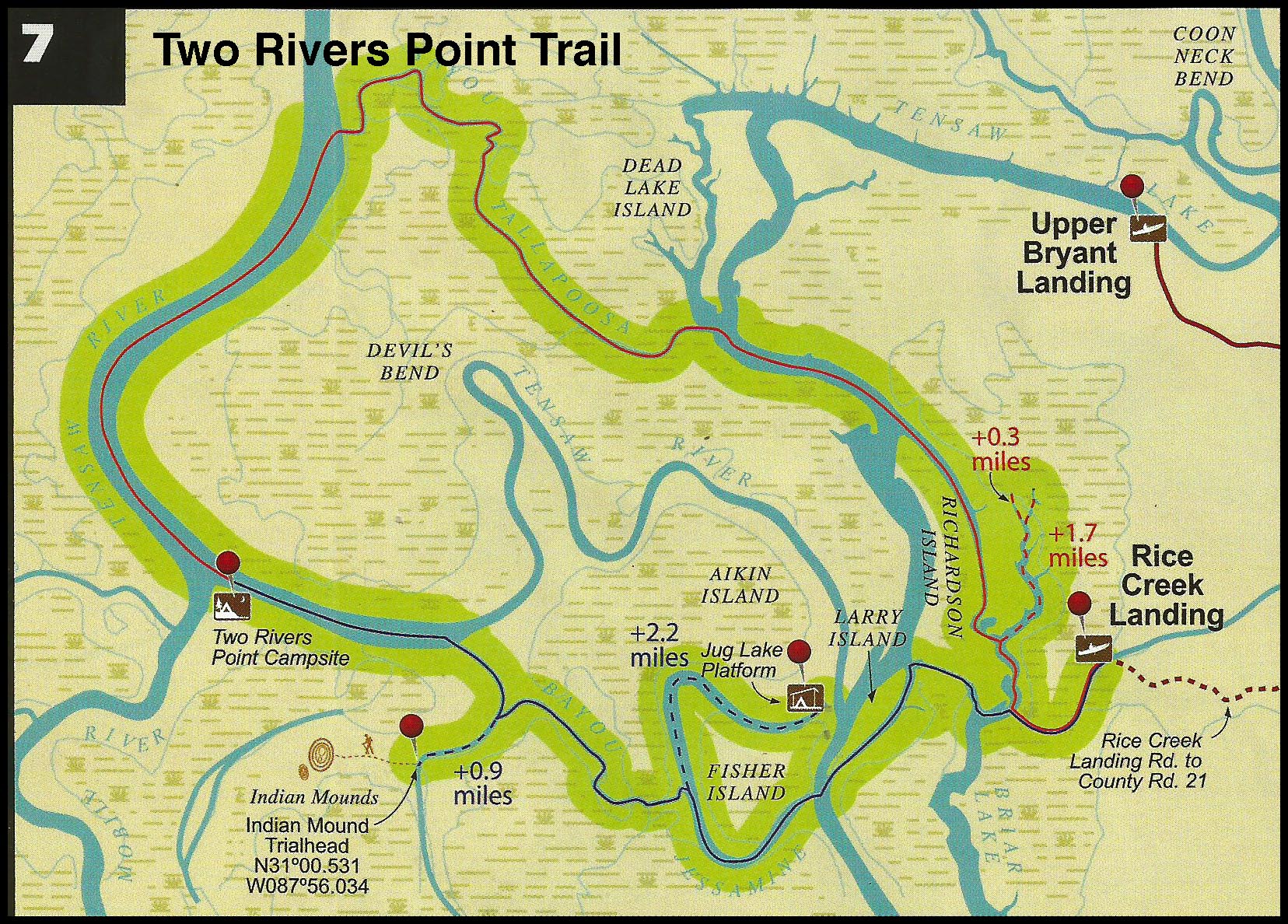
7. Two Rivers Point (2 days 1 night)
Distance: 14.1 miles
Start: Rice Creek Landing
End: Rice Creek Landing
Campsites: Two Rivers Point
Type of trail: old river channel, creek, lake, and slough
Habitats: bottomland hardwood swamp, flowing creeks, side channel sloughs and backwaters
Reliability: excellent
Recommended water levels: Claiborne Dam river stages ranging from l0 to 19 feet on tailrace readings provide optimum water levels for this route. Levels from l5-18 are the absolute best for the Globe and Bear Creek systems. River stages above these values should be considered hazardous. For water level information at Claiborne Dam, call 1-888-771-4601 or http://water.sam.usace.army.mil or http://al.water.usgs.gov.
The Overnight Route #1 begins at Rice Creek Landing, located on the Forever Wild Land Trust's Delta Tract, 2.9 miles north of the Highway 225/59 split in Stockton, AL, on Baldwin County Rd. 21. The map shows the trail proceeding out of Rice Creek, up Briar Lake and Tensaw Lake to Bayou Tallapoosa, through Bayou Tallapoosa to Tensaw River, down the Tensaw River to Two Rivers Point land based campsite. On day two the trail proceeds down the Tensaw River to Bottle Creek, down Bottle Creek to Bayou Jessamine, and then through this bayou to Tensaw River and back to Rice Creek Landing.
Bartram—Indian Mound
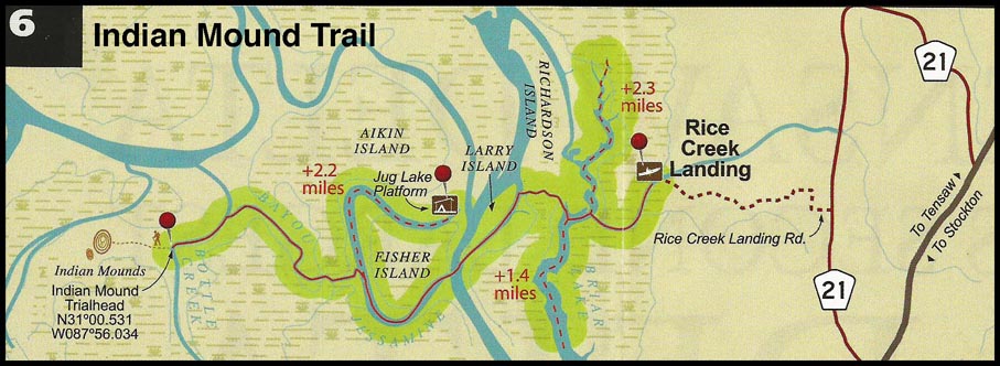
6. Indian Mound Trail (day use)
Distance: 9.1 miles (additional miles possible via adjacent sloughs and creeks)
Start: Rice Creek Landing
End: Rice Creek Landing
Type of trail: creek, lake, and slough '
Habitats: bottomland hardwood swamp, flowing creeks, side channel sloughs and backwaters
Reliability: excellent
Optimal water levels: Claiborne Dam river stages ranging from 6 to 19 feet on tailrace reading provide optimum water levels for this route. River stages above these values should be considered hazardous. For water level information at Claiborne Dam, call 1-888-771-4601 or http://water.sam.usace.army.mil or http://al.water.usgs.gov.
The Fisher Island day trail begins at Rice Creek Landing, located on the Forever Wild Land Trust's Delta Tract, 2.9 miles north of the Highway 225/59 split in Stockton, AL, on Baldwin County Rd. 21. The map shows the trail proceeding out of Rice Creek, around the south end of Richardson Island and past Larry Island, across Tensaw River and into Bayou Jessamine. The Trail then splits from Bayou Jessamine, proceeding north into a body of water known locally as "Jug Lake, " which bends around Fisher Island. The return leg follows the same route. Paddlers have several options for selecting the length and duration of this day-trip, especially when incorporating side trips.