Author Archives: John Hayes

Bartram—Fisher Island

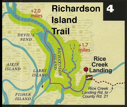
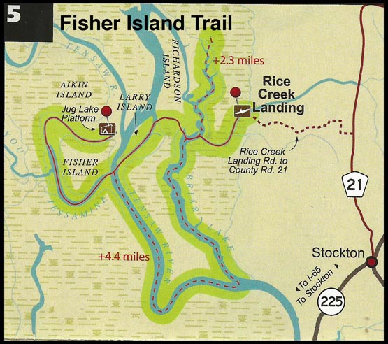
5. Fisher Island Trail (day use)
 
Distance: 8.9 miles (additional miles possible via adjacent sloughs and creeks)
 
Start: Rice Creek Landing
 
End: Rice Creek Landing
 
Type of trail: creek, lake, and slough
 
Habitats: bottomland hardwood swamp, flowing creeks, side channel sloughs and backwaters
 
Reliability: excellent
 
Optimal water levels: Claiborne Dam river stages ranging from 6 to 19 feet on tailrace reading provide optimum water levels for this route. River stages above these values should be considered hazardous. For water level information at Claiborne Dam, call 1-888-771-4601.
 
The Fisher Island day trail begins at Rice Creek Landing, located on the Forever wild Land Trust’s Delta Tract, 2.9 miles north of the Highway 225/59 split in Stockton, AL, on Baldwin County Rd. 21. The maps show the trail proceeding out of Rice Creek, around the south end of Richardson Island and past Larry Island, across the Tensaw River and in Bayou Jessamine. The Trail then splits from Bayou Jessamine, proceeding north into a body of water known locally as Jug Lake, which bends around Fisher Island. The return leg follows the same route. Paddlers have several options for selecting the length and duration of this day trip, especially when incorporating side trips.

Bartram—Richardson Island

4. Richardson Island Trail (day use)
 
Distance: 4.0 miles (additional miles possible via adjacent sloughs and creeks)
 
Start: Rice Creek Landing
 
End: Rice Creek Landing
 
Type of trail: creek, lake, and slough
 
Habitats: bottomland hardwood, flowing creeks and backwaters
 
Reliability: excellent
 
Optimal water levels: Claiborne Dam river stages ranging from 6 to 19 feet on tailrace reading provide optimum water levels for this route. River stages above these values should be considered hazardous. For water level information at Claiborne Dam, call 1-888-771-4601.
 
The Richardson Island day trail begins at Rice Creek Landing, located on the Forever
Wild Land Trusts Delta Tract, 2.9 miles north of the Highway 225/59 split in Stockton, AL, on Baldwin County Rd. 21. The map shows the trail leaving out of Rice Creek, around Richardson Island, and back to Rice Creek Landing. Paddlers have several options for selecting the length and duration of this day-trip.

Bartram—Douglas Lake Trail

3. Douglas Lake Trail (day use)
 
Distance: 10.2 miles (additional miles possible via adjacent sloughs and creeks)
 
Start: Upper Bryant Landing (private; public use fee associated)
 
End: Upper Bryant Landing (private; public use fee associated)
 
Type of trail: creek, lake, and slough
 
Habitats: bottomland hardwood swamp, flowing creeks, side channel sloughs and backwaters
 
Reliability: excellent
Optimal water levels: Claiborne Dam river stages ranging from 6 to 19 feet on tailrace reading provide optimum water levels for this route. For water level information at Claiborne Dam, call 1-888-771-4601.
 
The Douglas Lake day trail begins at Upper Bryant Landing, located north of Stockton, AL, on Baldwin County road 21. The map shows the trail leaving Upper Bryant Landing proceeding upstream on Tensaw Lake, into Douglas Lake to the end of the channel. The return leg follows the same route. Paddlers have several options for selecting the length and duration of this day-trip.

Bartram—Red Hill/Proctor Creek

2. Red Hill/Proctor Creek Trail (day use)
 
Distance: 6.5 miles all
 
Start: Hubbard Landing
 
End: Hubbard Landing
 
Type of trail: creek, lake, and slough
Habitats: bottomland hardwood swamp, flowing creeks, side channel sloughs and backwaters.
 
Reliability: excellent
 
Optimal water levels: Claiborne Dam river stages ranging from 6 to 19 feet on tailrace reading provide optimum water levels for this route. For water level information at Claiborne Dam, call 1-888-771-4601.
 
The Red Hill/Proctor Creek Trail day trail begins at Hubbard Landing, located south of Forever Wild Land Trust's Clearwater Tract.

Hubbard's Landing is located north of Stockton, AL, at the end of Baldwin County road 96. The route leaves the landing and proceeds upstream on Tensaw Lake to Proctor Creek, then continues upstream on Tensaw Lake slough and Red Hills Creek. The map shows that paddlers have several options for selecting the length and duration of this day-trip.

Bartram—Globe Creek Trail

Globe Creek Trail (day use)
 
Distance: 6.8 miles (additional miles possible via adjacent sloughs and creeks)
 
Start: French's Lake Coastal Access Kiosk
 
End: Hubbard Landing –
 
Type of trail: creek, lake, and slough
 
Habitats: bottomland hardwood swamp, flowing creeks, side channel sloughs and backwaters.
 
Reliability: excellent
 
Optimal water levels: Claiborne Dam river stages ranging from 10 to 18 feet on tailrace reading provide optimum water levels for this route. Levels from 15 to 18 are the absolute best for the Globe and Bear Creek systems. River stages above these values should be considered hazardous. For water level information at Claiborne Dam, call 1-888-771-4601.
 
The Globe Creek Trail begins at the French's Lake Coastal Access Kiosk, located on the Forever Wild Land Clearwater Tract. Get to French's Lake Coastal Access Kiosk by traveling north of Stockton, AL, on Highway 225/59. Follow signs to the Upper Delta Wildlife Management Area and then follow signs to French's Lake Coastal Access Kiosk. The map shows French's Lake as a small slough-like area on Major's Creek, prior to the creek splitting into several channels. Globe Creek is one of these channels. The multiple channels can be confusing, so it is to closely follow the marked route. Globe Creek route follows a generally southern direction into Big Beaver Creek, then into Tensaw Lake and ends at Hubbard Landing.
 

Tintop Campground


Tintop Campground and Trailer Park

CAMPSITE NUMBER  
COORDINATES Latitude  32.400025    Longitude -86.434058
 
CAMPSITE NAME Tintop Campground and Trailer Park
ADDRESS  
TELEPHONE  334 549 2141 Jeff Romeo, Manager
NOTE Located on the Alabama River south bank 1.5 miles upstream of the mouth of Autauga Creek (which is on the north bank of the river) at Alabama River Mile 276.5
MOTEL/CABINS  No
CAMPING RV and tent camping, fee charged
WATER Some sites
ELECTRICITY Some sites
SHOWERS No
FIRE RING No
TOILETS No
FUEL No
SUPPLIES No
LAUNDRY No
DOCKS No
BOAT LAUNCH RAMP For registered campers
SHUTTLE SERVICE No
ACCESS FROM ROAD Yes, via private road


Zane’s Retreat

# 106.3 + 2.0 / Left
Coordinates: 33*46’02. 14 N x 86*00’31.74 W

Address: On South side of the creek, upstream two river miles (mild current) from Hart’s Ferry / Ohatchee put-in ramp. Sometimes the current reverses when the dam releases. Private and quiet. Cleared field area. Natural rock ramp. Need to call him first – Cell 256-310-7679, home 256-419-4505; bring portable potty.
Note: This is private owned land below owner’s home on hill

MOTEL/CABINS  No
CAMPING Tents: Yes – Free/No Fee
WATER No
ELECTRICITY No
SHOWERS No
FIRE RING Yes
TOILETS No
FUEL No
SUPPLIES No
LAUNDRY No
DOCKS No
BOAT LAUNCH RAMP Yes, natural rock
ACCESS FROM ROAD No

Weogulfka Creek

CAMPSITE NUMBER # 9 / Left
COORDINATES Latitude 32.91833  Longitude  -86.41167
CAMPSITE NAME Horse Stomp Campground
ADDRESS SW of Weogulfka, AL in Coosa County, AL
TELEPHONE None
NOTE Very remote area
MOTEL/CABINS No
CAMPING .Yes – Primitive
WATER Some by well pump
ELECTRICITY No
SHOWERS No
FIRE RING No
TOILETS Yes- Primitive
FUEL No
SUPPLIES No
LAUNDRY No
DOCKS No
BOAT LAUNCH RAMP No
ACCESS FROM ROAD Yes
SHUTTLE SERVICE No

Weeks Bay – Camp Beckwith

CAMPSITE NUMBER  620 Left
COORDINATES LAT N 30* 23.283 / LON W 087* 50.009
CAMPSITE NAME Camp Beckwith
ADDRESS 10400 Beckwith Lane, Fairhope, AL 36532-6060
TELEPHONE 251-928-7844, John Koch, Executive Director
NOTE Call ahead please to assure availability; cabins, dormitory, rest room facilities available.  This is off of Mobile Bay up in Weeks Bay, and is a facility of the Episcopal Church.
MOTEL/CABINS Cabins, Yes – Fee
CAMPING RV: No    Tent: Yes, no charge.  Landing, fire ring, & camp area on beach, north side of long pier.
WATER Yes
ELECTRICITY No
SHOWERS No
FIRE RING Yes
TOILETS Yes
FUEL No
SUPPLIES No
LAUNDRY No
DOCKS Yes
BOAT LAUNCH RAMP Yes
ACCESS FROM ROAD Yes
SHUTTLE SERVICE No


Two Rivers Point

Two Rivers Point (land) – Bartram Canoe Trail


CAMPSITE NUMBER  
COORDINATES N 31.01968, W-87.96262
CAMPSITE NAME Two Rivers Point
ADDRESS Alabama Bartram Canoe Trail
TELEPHONE Water fluctuations 888-771-4601
NOTE Reserve online www.outdooralabama.com/outdoor-adventures/bartram.cfm
MOTEL/CABINS No
CAMPING Yes – on Land — primitive – bring your own portable potty
WATER No
ELECTRICITY No
SHOWERS No
FIRE RING No
TOILETS No – you must bring your own – and take it out
FUEL No
SUPPLIES No
LAUNDRY No
DOCKS Yes
BOAT LAUNCH RAMP No
ACCESS FROM ROAD No
SHUTTLE SERVICE No